SUMMARY
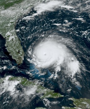
NOAA's GOES-R weather satellites capture detailed images of hurricanes using the Advanced Baseline Imager (ABI), positioned 22,236 miles above the equator. Unlike traditional cameras, the ABI does not rack focus or use a conventional shutter; instead, it collects measurements across 16 spectral bands, most of which are invisible to the human eye. These measurements are then reassembled into images on the ground, providing meteorologists with continuous, high-resolution views of storm development. The geostationary orbit allows the satellite to maintain a constant view of the same hemisphere, enabling continuous monitoring of storms as they form and move.
TAKEAWAYS
NOAA's GOES-R satellites use the Advanced Baseline Imager (ABI) for hurricane imaging.
The ABI captures data across 16 spectral bands, including visible and infrared light.
Images are assembled from measurements, not traditional photographs, and refreshed every 60 seconds.
The satellite's geostationary orbit allows for continuous observation of storms.